Tuesday, December 29, 2015

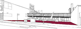
7022-7036 N. Clark


Here's a diverse group of buildings on the west side of Clark Street south of Greenleaf.  As random as these look they document the variety of forms that contribute to a traditional neighborhood commercial strip.

L. Shure, 2015

Clark and Greenleaf intersection
The wood-frame building in the center represents a type of commercial construction which has nearly disappeared in Chicago. Let's just say fire and wood is not a great match.  The first floor has been oddly clad with a red brick veneer.  Originally this would have had cast iron columns framing large glass and wood storefronts.  I'm really not sure how this got on the block.  Fire codes would have prevented this type of construction and I doubt this building pre-dates the 1893 annexation of Rogers Park.  As you can see from the 1958 photo below it originally had a projecting bay on the second floor and a false front. 

1958 Photo from the Images of Change collection at UIC

The red brick building on the right was built around 1913 with white terra cotta cornice and window surrounds.  It still retains a good amount of character, although the huge red awning (fiberglass?) makes it look dated.  This is a traditional mixed-use building with storefronts below and apartments above. The south storefront has been infilled and covered with a red and white pebble finish. This was a bar when I first moved to the neighborhood.

The yellow and blue 1-story building dates from at least 1958...  The storefront angles back slightly from the sidewalk  to create a shallow entrance.  I'm guessing there are roughly a thousand coats of paint on this one. The sign dominates the building, which became common as new buildings focused only on retail or commercial use.

The gray building to the left is constructed of split-face concrete block (CMU).  This may be the most unattractive masonry material ever produced.  I can date this building to around 1986, but I'm a little surprised by the huge sign above the roofline.  Current sign codes prohibit new signs taller than the building.  This could be older building that kept its signage.  Or maybe they just never bothered to get a sign permit...

Despite their varying vintages and forms all of these buildings come right up to the sidewalk and observe a similar scale and relationship to the street.  And even with their mix of materials they somehow seem to harmonize with each other.

Monday, December 28, 2015

Beachton Court Apartments, 1929

Image above from the Tribune Article, 11/11/28
The Beachton Court Apartments are another example of how Rogers Park rapidly gained density at the end of the 1920s.  This complex replaced the Raymond Beach residence at the southwest corner of Pratt and Ashland and was named in honor of the former occupant. Not sure if he appreciated that or not...  Raymond Beach must have been a holdout in that area as many single family homes gave way to 3-story apartment buildings.

The steel-reinforced cement frame building has an exterior of buff brick and stone cladding.  It had a large community room on the first floor (maybe it still does?) including a waxed dance floor. The 76 units had built-in ironing boards, vestibule phones, electric door releases and electric refrigeration.  The architectural style is described as Tudor Gothic, modified to 1928 sensibilities.  I take 1928 sensibilities to mean tall and massive.

The rendering shows parapets with ornament that projects above the building, giving it a slightly more vertical orientation.  I'm not sure of these elements were removed or perhaps not built as drawn.  It was constructed at a cost of $580,000.

Site Map
Leon F. Urbain was the architect for the building as well as an investor.  I find this to be common for large apartment buildings. Successful practices often incorporated design and development, which must have solved many problems.  And possibly created some as well.

Images from Google Streetscape
Urbain designed at least two large apartment buildings at various stages of completion by 1929.  With the stock market crash these were put on hold until new financing could be secured.  The Poinsettia Apartments in Hyde Park and the Kenmore Manor Apartments in Edgewater were similar in scale to the Beachton.

The project on Kenmore sat for 7 years until it could finally be completed.

Just a quick note.  Leon Urbain should not be confused with the firm of Olsen and Urbain, which was also active in the area.  I'm mostly talking to myself here.

Complete Tribune Article 11/11/28


Wednesday, December 16, 2015

Metra's 1965 Ravenswood Corridor (Repost from 6/5/14)

Metra Overpass at Greenleaf, looking North

I take the UP-N Metra train to work every morning and home every evening.  It may possibly be the best and easiest commute in the universe.  While I'm waiting for the train sometimes I notice things from the platform, like these standard 1960s apartment buildings flanking the west side of the embankment.

Ravenswood is split by the train line, so there's a Ravenwood Avenue on either side south of Lunt.  But at Lunt the west side of Ravenswood ends abruptly.  At that point a series of condo buildings occur between Lunt and Touhy, located in the same strip where Ravenswood would have continued through.


These brick buildings (shown in red above) are nearly identical, with low pitched roofs and simple geometric ornament. Some of them are bigger than others, which basically means that a few more units have been tacked on.   A quick check of the Cook County Assessor's website shows that all of them are dated to 1965. 

I'm guessing it's not a coincidence.  That strip of land had been owned by the railroad (at that time the Illinois Parallel Railroad Company) since its incorporation by the Illinois Legislature in 1851.  Passenger service to Waukegan began in 1854, with service to the North Shore beginning in 1856.  By 1869 there were seven trains each way daily.  In 1896 work began to elevate the tracks above grade in an effort to eliminate crossing accidents.

Sanborn Map above and Chicago Zoning Map below
Public rights-of-way have enormous value, even just from a standpoint of square footage.  Railroad rights-of-way were granted to private industry because they had the capital to develop them for public (and private) benefit.  But what happens when the railroad doesn't have a need for as much land as it was given? Does it return that land to the government?  In this case it appears to have been sold off for residential development.

To the right is a Sanborn Fire Insurance map from 1937, showing the previous ownership structure for the area.  The train platform on the west side of the tracks is clearly outlined.  At first I thought that perhaps the railroad bought this land, but if that were the case the alley would extend through.  Instead, I believe this area was part of the granted right-of-way, and was used to provide access to the Rogers Park station.  It also provided a buffer between the trains and the nearby single family homes.

But sometime after 1937 it was determined that this land no longer served the interests of the railroad.  Perhaps the train platform was reconstructed to take up less space. Or perhaps the railroad needed to raise funds.  Regardless, the areas adjacent to the tracks were developed into multi-unit buildings.  North of Touhy the railroad has retained ownership, possibly because the slightly westward angle of the route made the lots less viable for development. 

To me the front facades look a bit like drunken robots.  The developments also created an uncomfortable relationship between the train embankment and the new buildings.  The area in between is a dark, overgrown strip which frequently fills up with trash.  Perhaps not the best land planning, but a good example of how developers maximum the value of undesirable lots.   As if we needed more of those examples...

Metra posts some history about their train lines here, which provided some of the detail and dates above.

Wednesday, December 2, 2015

6970-6972 N. Clark (c.1988)


Above is a standard strip mall in Rogers Park.  These are scattered throughout the neighborhood and are the primary design for auto-oriented businesses along Clark Street.   They are often located on corner lots, which provides frontage on two streets and greater visibility. This one is located mid-block, which is unusual.

The photo is dated 1958 from the UIC Collection "Images of Change."  The Sanborn Map is from 1951.
This particular strip mall replaced a 6-story hospital and a 3-story mixed-use building.  Both came right up to the sidewalk. As far as I can tell both were demolished some time in the 1970s.


Parking and Circulation

The most important thing about strip malls is the parking lot. Without a parking lot the advantage of the design is lost.  In this case almost every square foot has been given over to parking and circulation. 


Primary Sign

The second most valuable feature of the strip mall is signage.  A large sign provides identification for each business on the strip.  These signs are generally as big as can be permitted by current sign codes.  Signs are designed for cars driving past rather than pedestrians.

Sign Band


The sign band is for individual business signs and is designed to easily accommodate mechanical and electrical connections.  If the sign band is damaged it can be repaired by replacing the cladding.
Secondary Signage


Because the strip mall design creates a break in the street wall it exposes the unfinished walls of the neighboring buildings.  Often these are used for signage as well.

Despite the large amount of space dedicated to signage individual tenants still manage to place additional signs and advertising on the site.  Here flags have been attached to the sign band, bunting has been strung from the primary sign to the building, and a feather sign has been placed in the planting strip.
Bollards

Planting Strip

Because the strip mall brings the cars in close to the storefronts additional devices are needed to prevent them from accidentally crashing through.  In this case concrete parking stops and metal bollards are used.  


More recent strip malls include areas for landscaping.  Here a long narrow concrete planter has been located at the front of the lot.  Given the size of the strip and its proximity to car exhaust and melting salt nothing can actually grow here.  It some point it was paved over.  In the winter this is where snow is piled.


Over the years there has been a realization that strip malls are not the most appropriate development for established commercial districts which rely on foot traffic from the adjacent neighborhood.  Special zoning overlays can prohibit this type of development, but the community needs to be sophisticated enough to ask for these additional controls.  And in many places the damage has already been done.