Showing posts with label zoning. Show all posts

Monday, November 7, 2016

Anatomy of a Small Urban Plaza - Jarvis Square

Aerial view looking South. Plaza outlined in green.
The outdoor seating areas along Sheridan Road aren't the only examples of unexpected urban plazas in Rogers Park.  At the southeast intersection of Jarvis and Greenview, just east of the el station, there's a 3-story brick and terracotta building that's substantially set back from Jarvis to create a generous plaza. 

As with many older Chicago neighborhoods, Rogers Park developed commercial districts around its public transit nodes. This was especially true around neighborhood el stations. Areas adjacent to stations functioned as primary or secondary commercial districts for the community, with development right up to the front property line.  The first floor would consist of storefronts and offices to serve the commuters, and affordable apartments would be found on the second and third floors above.

Detail of an 80-acre map showing subdivision setbacks.
Areas that were further away from transit were expected to develop as residential districts with single family homes, two- and three-flats, and larger apartment buildings like Chicago's classic courtyards. The density of any given street was based on the cost of the land; the more expensive the land, the greater number of units that could be expected.  Early development close to Lake Michigan consisted of single family homes.  But as the desirability of the area increased in the 1910s and 1920s, those same blocks began to support larger apartment buildings.

Zoning requirements in Chicago were only imposed in 1923, so subdivision setbacks, which were basically private agreements recorded to the parcels, were utilized to guarantee generous front yards and a consistent appearance of a block.   The map above shows lots the area immediately adjacent to the El  (with no setbacks)  while the green areas indicate a required 30 foot "front yard" setback.

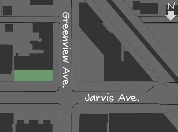
Building footprints with Jarvis Square in green.
But, on rare occasions, the single family homes never moved in. The lots, which were still tantalizingly close to the public transit corridor, developed into standard mixed-use buildings with storefronts and offices on the first floor and apartments above. What would have otherwise functioned as a front yard became a private plaza. This seems to be what happened at the southeast corner of Jarvis and Greenview.

In recent years the Jarvis plaza has been recognized for the neighborhood amenity that it is.  It has been elaborately paved, filled with flowering plants and prairie landscaping, and enclosed with a decorative cast iron fence. The building's storefronts have seen a succession of quirky Rogers Park businesses including Don's Coffee Club, which was basically like awkwardly ordering coffee in someone's living room, as well as lefty used bookstores, black box theater companies, and antique shops. The plaza was even the site of the Rogers Park Prom (1996 to 2000?), a peculiar local event that seems to have faded into the mists of time. But the plaza is still there,  so perhaps the Prom will someday be revived, with a few ironic vintage prom dresses, a skilled DJ, and a dash of Rogers Park's neighborhood spirit.

View of Jarvis Square looking East.


Tuesday, July 8, 2014

2328 W. Touhy, 1932

I've always been fascinated by isolated storefronts tucked into residential areas.  Some of these are very successful, but most struggle away from the major commercial corridors and foot traffic.  Chicago has plenty of these first floor commercial spaces scattered throughout the city, remnants of a time when a corner store was a necessity.  The one-story stucco box at Touhy and Claremont has seen better days, but there it remains, looking for a new tenant after that print shop folded. 

Northeast corner of Touhy and Claremont in the West Ridge neighborhood

Many of these areas you can track to the 1923 Zoning Code of Chicago.  When this ordinance was adopted most major streets received commercial designation, but odd little neighborhood intersections were also zoned commercial.  With adoption of the 1957 Zoning Code these were scaled back, but in places which developed according to the earlier code you'll find a variety of enclaves, ranging from odd little strip malls to elaborate Victorian storefronts. Often several of these will be clustered together.

So why would only the north side of Touhy be zoned commercial?  I'm guessing that the map formalized conditions which existed  prior to 1923 as much as it guided future development.  Want to know where to put commercial?  How about where it's already been built? Who's going to complain about that?

On one hand, it's difficult for these buildings to become the focus for a neighborhood.  On the other hand, sometimes they do. Just take a look at the commercial buildings at a typical stop on the Red Line. 

I would hate to see these little neighborhood nodes disappear.  Sometimes they become perfect incubators for unusual businesses.   Areas which are less desirable often have lower rents, and there's where you might find artist's studios, storefront theaters, used book stores, and coffee bars. These are the things which give a neighborhood texture and variety, and make city living a bit more awesome.

Anyone want to start a grocery co-op in an old print shop?

Wednesday, July 20, 2011

1923 Zoning Code, Rogers Park, and Courtyard Apartments


Rogers Park, 1923 Zoning Ordinance
This is my colorized version of the Volume District map for Rogers Park, adopted as a part of the 1923 Zoning Code. There were five volume districts created throughout the city, but only districts 1, 2, and 3 were mapped in Rogers Park. 


I find zoning maps interesting, especially when they represent the first attempt of a city to get a handle on it's own development.  Does it reflect the neighborhood character or aspirations for the future?  Generally it's an interweaving of the two.


You can see that the greatest volume was assigned to the area adjacent to the lakefront.  This was a typical pattern for the 1923 code.   With a maximum permitted height of 195' the blue zone would have allowed 20 story buildings throughout the area.  It's hard to imagine what Rogers Park would be like if that had happened.  Even the least dense district 1 (yellow) would allow buildings around 6 stories. As the legendary Homer Hoyt once observed, if Chicago had been built-out to the extent permitted in the 1923 Zoning Ordinance it would have housed the entire population of the United States.

7062-7078 N. Wolcott, 1931
So what's really going on here?  One  answer is that the map represents the ideal distribution of land uses and densities over time. But ideal for who? 

The creation of these maps followed a survey and planning process where existing development was cataloged and future needs were anticipated.  The ordinance itself was shaped by volunteer commissioners, city planners (still a new profession), and members of the Chicago Real Estate Board.  As others have observed, city planning makes for an odd combination of entrenched financial interests and idealistic social scientists with an unshakeable belief in the power of rational land-use.  There are always disconnects between the two.  As developers know, there's some value in pointing to an official city document and assuring potential investors that they can build their 20-story apartment on the site.

This is my colorized Use District map for Rogers Park showing the locations zoned for industrial, commercial and residential development.  Rogers Park's major commercial thoroughfares were (and are) Clark, Devon, Morse, and Howard. If you're familiar with the neighborhood you'll notice several additional commercial areas.  Many of these never developed the way the zoning map envisioned, or at least not to the extent shown. 

A criticism of the 1923 code was that it didn't allot enough area as residential districts.  But by 1923 there were fewer single family homes being built in Rogers Park.  In fact, every major metropolitan area saw a surge in the construction of multi-family buildings.  But even if the entire neighborhood had been zoned to encourage the least dense development it would have still permitted the construction of 6-story apartment buildings side-by-side with single-family homes.  The 1923 code was not a tool intended to limit development, but rather to make it more predictable and consistent.


This is my attempt to geocode a list of courtyard apartments.  For the purposes of this study these are generally 3-stories in height with a raised basement built roughly between 1915 and 1930. Special thanks to BatchGeo.  Most of these buildings were built after the 1923 code, so it's interesting to see the wide distribution.  Based on the 1923 code there were no districts which would have prohibited their construction.  Although there are a few clusters, but they don't seem to directly relate to the zoning maps.  I suspect the most significant factors governing their location were economic.  But the distribution map provides a spatial sense of how these building types relate (or don't) to the formal zoning goals of the city. 


1638-1646 W. Farwell, 1929
I can't end this post without referencing Joseph Schweiterman's and Dana Caspall's book, "The Politics of Place:  A History of Zoning in Chicago."  They provide a coherent framework for understanding Chicago's zoning system, and much of the background information above was stolen from them.  Definitely worth reading.

Next week is vacation!  So the next post may be even slower than usual...