Showing posts with label Rogers Park. Show all posts

Thursday, October 1, 2026

Stucco Bungalows of West Ridge

These are some of my favorite examples of a cluster of stucco bungalows along N. Maplewood and N. Campbell Avenues.  They were permitted in 1919 by Chicago architect/developer Niels Buck just as the formerly rural West Ridge neighborhood began to urbanize.

Niels Buck (1866-1928) was no stranger to speculative development.  A Danish immigrant who had trained near Copenhagen as a cabinetmaker, he picked up his architectural knowledge while working in the building industry. In 1893, he began his own practice, primarily focusing on multi-family apartments and single-family homes in the Edgewater and Uptown areas. But I believe his greatest contribution to the city was developing groups of high-quality affordable housing in the 1910s.  
Buck's first large-scale development was a cluster of 36 frame bungalows in the Edgewater neighborhood completed in 1915. Most of them are still there, bounded by W. Bryn Mawr, N. Ravenswood., the alley north of W. Olive, and N. Hermitage.  Like many early Chicago developers, Buck & Co. offered homes on the installment plan.  One could buy a two-bedroom home with a porch for a $300 downpayment, and a monthly cost of $15, plus interest.  In a time before standardized mortgages, community builders were a path to homeownership for many working-class families.

Even before the homes were sold Buck was on to another development one mile north in Rogers Park.  This was a group of 50 bungalows on Arthur Ave. between Clark St. and Ravenwood Ave. For these homes Buck & Co. had switched from frame construction to fireproof construction. These two- and three-bedroom homes were priced at $4,400 to $5,500 and required a downpayment of $300 to $500.  I wrote about these in a previous blog, which you can read here. 
In a 1915 article in Building Age, Buck explains how he made fireproof construction cost-comparable to frame houses.  Buying large amounts of building materials let him save money through economies of scale, while building very similar homes created an experienced crew that required minimal supervision.  In addition, new modern building materials simplified construction details without sacrificing quality. Two floor plans were available- one with five rooms, and one with six.  All incorporated at least one porch. Buck even gave some thought to harmonious colors, offering buyers stucco in white, gray, lemon and brown and a choice between dark red, green, or slate gray asphalt shingles. 

After their Rogers Park project, Buck and Co. became even busier.  In 1919, they advertised thirty more bungalows in the Belmont Cragin neighborhood, on a block bounded by W. Diversey, N. Cicero, W. Parker, and N. Kilpatrick Avenues.  These are nearly identical to the tile-and-stucco homes developed on Arthur, down to the geometric timber patterns on the stucco. 
In 1921, Buck and Co. advertised 100 new homes in the Portage Park area, within a site bounded by W. Berenice, N. Central, W. Waveland, and N. Linder Avenues. For this development, they returned to their earlier frame construction, with minimal variation in facade or massing. 

And finally, we make it to West Ridge!  In 1923, advertisements appeared for the stucco bungalows on Maplewood and Campbell Avenues.  These 30 homes were permitted in 1919, so they were likely available earlier. Niels utilized the tile-and-stucco construction here.  Perhaps he believed the demand would be strong near the developing Western and Devon commercial district, which had benefited from the expanding streetcar network.

The Campbell/Maplewood development appears to be Buck & Co.'s last large-scale project.  They remained active in real estate transactions, but the construction side of the business seems to have begun to wind down.  A few years later, Niels Buck passed away at age 62, leaving behind hundreds of small homes that still add to the city's affordable housing supply.

Buck and Co. Developments.


Selected Sources

Leroy Blommaert and Marsha Holland.  Edgewater Historical Society Webpage, "Niels Buck, Edgewater Architect."  https://www.edgewaterhistory.org/ehs/local/Niels-Buck-Edgewater-Architect.
Accessed 10/1/26.

Who's Who in Chicago. United States: A.N. Marquis & Company, 1926.

Building Age. United States: David Williams Company, 1915.

"Niels Buck and Herman Becker to Construct Homes Costing $250,000 on Ashland Avenue," Chicago Tribune, December 12, 1914, 18. https://www.newspapers.com/image/354960041/

"Obituary - Niels Buck," Chicago Tribune, June 17, 1928, 13.

Sunday, August 2, 2026

Washtenaw-Sherwin Homes, 1946-1953

(An earlier version of this article was published on the site in 2015.)

When WWII veterans returned home, they faced a severe housing shortage.  One government remedy was to repurpose housing built for war workers into inexpensive rentals for returning soldiers and their families. Areas identified for temporary housing were typically government-owned and sparsely developed. And this is how a series of pre-fab homes ended up in an undeveloped park in West Ridge.
Current Aerial image of Rogers Park showing the 
location of the temporary veterans housing in red. 
During WWII, the demand for housing to support the war effort jump-started the prefabrication industry, which had long promised mass-produced, inexpensive homes.  Wartime contracts sometimes resulted in cities appearing practically overnight.  A memorable example is Oak Ridge, Tennessee, where 75,000 people were housed and employed to process the uranium needed for the Manhattan Project.  At the end of the war, these homes (and similar ones across the country) were considered surplus and made available as emergency housing for returning veterans.  Residential structures from Oak Ridge actually ended up in Chicago's Hanson Park area.
 
In the West Ridge neighborhood, the Chicago Board of Education (which built the nearby Rogers School in 1936) leased a 10-acre plot to the Chicago Housing Authority, which received City of Chicago funding to prepare the site and install utilities.  But it was not clear sailing.  Mayor Edward Kelley sought greater Federal reimbursements, freezing the program in the summer of 1946 until he was satisfied that the Federal Government would provide additional financial support. 

Although the area was sparsely developed, nearby residents were not pleased.  They didn't see temporary housing as a good way to increase property values, and they knew the area would soon attract private development.  They petitioned CHA to choose another site but were reassured that all temporary housing for veterans would be demolished within three years. The project moved forward.
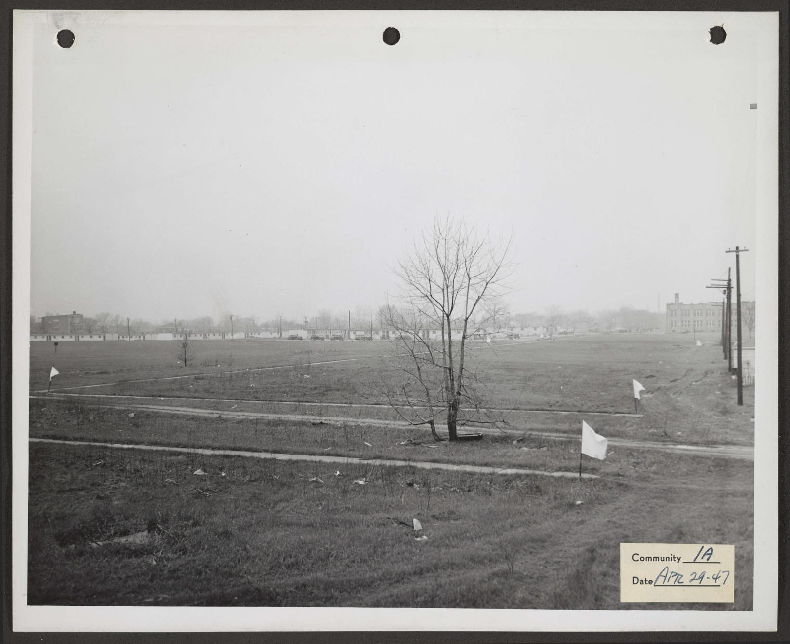
Chicago Park District photo with the Washtenaw-
Sherwin veterans' housing in the far distance (1947). 
Accessed through the Explore Chicago Collections at 
https://explore.chicagocollections.org/image/chipublib/247/nk37s08/
Soon, twenty panelized buildings relocated from Seneca, Illinois, and Evansville, Indiana stood on the formerly vacant land south of Rogers School.  Twenty-five feet wide and 116 feet long, each one-story barrack-like structure accommodated six families.  To allow the installation of demountable residences, Kelly's City Council had also waived the Chicago Building and Fire Codes.  

The temporary housing program also had a racial component.  Of the returning veterans, 20% were black. Previously, CHA based its racial policy on the Neighborhood Composition Rule, which meant that public housing observed the predominant racial makeup of the surrounding area.  In 1946, this was changed to support a policy of integration.  Several of the integrated developments attracted anger and violence from surrounding white residents, including those near Midway Airport, Fernwood Park, and Edison Park.  It's unclear whether the Washtenaw-Sherwin Homes were integrated, but it seems unlikely. A change in leadership from Mayor Kelly to the less racially progressive Martin Kennelly likely also affected the CHA policy.  In the end, approximately half of the temporary veterans' housing projects were integrated.
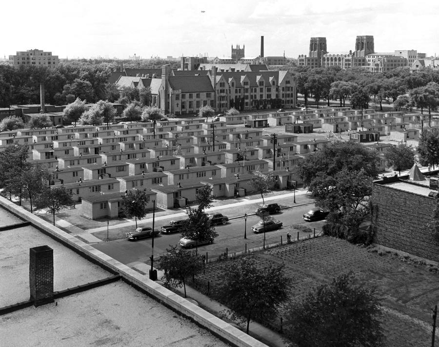
Temporary housing for veterans on the Midway
Plaisance near the University of Chicago campus (1951).
Accessed through the Explore Chicago Collections at
https://explore.chicagocollections.org/image/uchicago/94/xw48d8k/

 
In 1947, the Chicago Park District took the opportunity to acquire some of the surrounding land, and by 1950 a new 20-acre park had been established to the east.  

Despite CHA's promises, the trailers weren't removed until 1953.  By then, the homes had far outlived their design life, and many seemed unlikely to survive another Chicago winter. CHA moved remaining eligible families to permanent housing, and staff helped others find units in private developments. The underlying 10 acres were then absorbed into an expanded Rogers Park.

Collective memory of the temporary homes seemed to quickly fade.   In 1957, the Chicago Park District awarded a contract to further develop the park.  A Tribune article noted that the property had been used as a golf driving range, truck gardens, and a site for greenhouses.  But it doesn't mention buildings that housed 120 veterans and their families for seven years.

Of the twenty-three sites used for temporary veterans' housing in Chicago, very little evidence remains.  But while I was putting together the map for this post, I realized the large linden trees in the park sit between the north and south halves of the development, and perhaps they were planted to give the veterans and their families a sense of beauty and stability.  So maybe that's a small nod to history for those who know to look for it.

Map of Eighteen Remaining Temporary Housing Projects in 1951. Five trailer projects had already been demolished. Most sites were on the city's periphery. (Data from "Favor Razing of Temporary Vets Housing" noted below, with some intersections corrected/updated.)


Selected Sources

Bowly, Devereux. 2012. The Poorhouse: Subsidized Housing in Chicago. 2nd ed. Carbondale: Southern Illinois University Press. https://search.worldcat.org/title/801409203.

"Start Housing Projects this Week to Aid GIs," Chicago Tribune, Feb. 24, 1946, 152. https://www.newspapers.com/image/195831593/

"Vet's Housing Work is Slowed by Shortages," Chicago Tribune, April 7, 1946, 31. https://www.newspapers.com/image/371987881/

"Kelly Predicts U.S. Will Pay Funds for Veterans' Homes," Chicago Tribune, June 18, 1946, 3. 

 "City to Speed Opening of 724 Homes for Vets," Chicago Tribune, June 27, 1946, 9. https://www.newspapers.com/image/372476724/

"Here's Why Vets are Still Homeless," The Chicago Star, July 20, 1946, 16. https://www.newspapers.com/image/897873435/

"Favor Razing of Temporary Vets Housing," Chicago Tribune, October 18, 1951, 45. https://www.newspapers.com/image/370098790/

"Pontiac Homes, A Jalopy of a Village, Junked," Chicago Tribune, November 2, 1952, 197. 

"Rogers Park Contract Let for $246,177," Chicago Tribune, September 1, 1957, 85. 


Wednesday, June 13, 2018

1615 W. Morse Avenue - Mision Cristiana Elim


Immediately south of Mision Cristiana Elim is a parking lot along N. Ashland Avenue. This was originally intended for the main sanctuary of the previous owner, the Reform synagogue of Temple Mizpah, which I've written about here. This was never built, so the east side of the building remains exposed to the street.  

It's a bit strange, but I prefer this side of the building.  All of the loading and unloading spaces and mechanical accommodations are on full display. In many ways, it's more complex than the primary facade, constantly adapting as needed.


Friday, May 11, 2018

View from Goldberg Park

Looking up from Goldberg Pocket Park.

I'm interested in parts of buildings that were never meant to be displayed.  These spaces most honestly respond to the structure's needs and the materials' limitations.  Sometimes these are visible when an adjacent building is demolished, but you can also walk down any alley in the city. I find pocket parks create some great viewing galleries, and sometimes even a bench.  This view from Goldberg Park is one of my favorites.  
It's really a streetscape in its own right, following a set of rules just as compelling as those which govern the finished facades. 

Friday, May 4, 2018

View at Sheridan and Pratt

View from Sheridan looking Northeast towards Pratt.
Sometimes the spaces created between buildings are just as interesting as the buildings themselves.  I'm especially drawn to taller buildings with irregular footprints and deep courtyards.  The negative space creates  complex pinwheeling shapes that most people sense, but don't consciously appreciate.

I've written about both of these buildings before.  They represent the transition of Sheridan Road from a leisurely lane lined with mansions to a more dense and urban thoroughfare.

Here are the previous posts:

6801 N. Sheridan- Rogers Park Hotel, 1922

6757-6765 N. Sheridan, 1917


Monday, March 19, 2018

Pratt Lane Hotel, 1927

Detail of terra cotta brackets
This building was designed by Koenigsburg and Westfeld in the Gothic Renaissance Revival style and constructed in 1927.  The ornament has always fascinated me-- and in particular the lion brackets supporting the twin projecting bays.  The first drawing I did of the building was back in 2006, but apparently that graphic is trapped on a obsolete Photobucket server.  But here's a link to the previous post.

This was constructed as an apartment hotel, which was basically a month-to-month furnished apartment with communal dining and socializing areas.  Apartment hotels would typically include a regular cleaning service.  This is an urban type that hasn't survived in Chicago (as far as I know).  The closest  approximation I can think of is an extended-stay hotel, and those are now mostly found out by the highways.
1246 W. Pratt

This building dwarfs its neighbors, and would have been one of the few to approach the permitted height increase established by Chicago's first zoning code in 1923.  I think the entire lakefront may have followed suit if it hadn't been hit by the Great Depression.  So for now it remains a crazy outlier, catching the sun all day with it's amazing glazed white terra cotta.


Thursday, February 15, 2018

Stucco Bungalows on Arthur, 1915

Figure 1. Fifty Stucco Bungalows on Arthur Avenue

I've written several posts about collections of homes planned, designed, and built by early developers in the neighborhood.  These range from a few identical cottages to more complex arrangements.  These small-scale developments are found throughout Chicago, and their quiet existence probably accounts for most of the city's small-scale speculative residential development.

On the block of Arthur Avenue, with Clark Street to the east and the Union Pacific Railroad embankment on the west, stands an impressive collection of modest stucco bungalows built in 1915. Permit records show that Edgewater architect and developer Niels Buck designed these homes.  Two permits were issued: the first covered the homes on the north side of the block in April 1915, and the second covered the south side in October.

According to an article in the Chicago Tribune, Niels Buck, in partnership with Herman Becker, bought 12 1/2 acres in the area for $60,000 from Jacob Rehm in 1914. Construction costs were estimated at $230,000, likely including site improvements.
Figure 2. View from the west looking
towards Clark Street, 1921
.


This was a high-quality development, with poured concrete curbs, walkways, sidewalks, and electric streetlights.  The tile-and-stucco construction was just as sturdy as brick, but at a fraction of the cost.

Figure 2 is a great photograph of the street in 1921, when you could still smell the paint. The image is available on Wikipedia, which considers it too old to be subject to copyright.  Still, I'd like to know where it originated...

Real estate developers in the city were responsible for tying their development into the city's street grid and extending utilities.  Quality construction was profitable to the developer, who wanted homes to sell briskly so they could move on to their next opportunity.  And in 1915, affordable homes in Rogers Park, with its strong transit ties and proximity to the lake, probably went like hotcakes.

Figure 3. A sample of the bungalow designs.

Although these were basically the same in square footage, the changes in massing and design avoid the appearance of repetition.  This was an advantage of having a developer who also functioned as an architect. For those who look closely, the block creates an almost perfect illustration of architectural variations on a theme.

I put Figure 3 together when I thought the block was comprised of repeating building types. But in actuality, they all seem a bit different.  And after a hundred years of modifications, it's even harder to make that conclusion.

Figure 4. Bungalow with boulder cladding.
Many of the homes on the block have since departed from the original design intent.  Enclosing open porches was common, especially after affordable air conditioning became available.  Rear additions and detached garages are also common. I'm guessing garages weren't included in the original development in order to keep prices low.  Sometimes homes were expanded upward, losing the original roof shape but adding substantial square footage.

Stucco is a surface treatment that required maintenance, repair, and sometimes replacement.  It wasn't such a stretch to replace one surface treatment with another.  The bungalow in Figure 4 incorporates a formstone cladding.  This was popular for home repair as early as the 1930s and was probably a bit cheaper than new stucco, which requires specialized installation skills.

Figure 5. Bungalow with renovations.
The home in Figure 5 has been altered just as much as the one above, losing the open porch and extending a new covered entrance porch.  In this case, the renovations followed some established patterns on the block, retaining the stucco and eave brackets and incorporating more traditional window details.

This block of Arthur represents the most extensive contiguous development I've found in the neighborhood. But I know there are many more out there.

Figure 4. Ad for Atlas Portland Cement Company from
American Builder, May-1918.  Accessed through Google Books.

Somehow I keep finding more information about this street!  Below is a page from a booklet found on Archive.org.  It even includes a fuzzy floor plan and some more detail about the construction method.  The cost of the homes is noted as less than $3,000, which is about $54,000 in 2018. Wow.

Figure 6. Industrial Housing, National Fireproofing Company-  published 1918
and accessed via Google Books.


Wednesday, January 24, 2018

East Park Apartments, 1521 W. Sherwin, detail

In case you're wondering, those are holiday ornaments in the windows!
Art Deco terra cotta ornament is unusual in Rogers Park. Actually, Art Deco is unusual throughout Chicago, although there are still some great examples to be found.

According to the Chicago Historic Resources Survey this building was permitted in 1931 and designed by architect Benjamin A. Comm.  Most private building ceased after the crash of 1929, so I expect this project was funded well in advance.

What became the Art Deco style made its official appearance at the 1925 Paris Exposition.  It reflected contemporary movements in fine art, such as Cubism and Futurism, emphasizing pure geometric form and rejecting historic ornamentation.  So it's a bit ironic that same ornament has now become historic in its own right...

In 1927 the officers of the Northwestern Terra Cotta Company brought over six French sculptors to supply new designs for the company.  These became popular with architects and builders and soon the new style of ornament could be found at other terra cotta companies as well.  The use of color helped to emphasize the forms and lines of the design, which typically had a lower relief than  traditional ornament.

Some buildings designed by Benjamin A. Comm showing various styles.
Benjamin A. Comm designed a number of buildings recognized in the Chicago Historic Resources Survey.  His most interesting design (as far as I know) was the Union Park Hotel at 1519 W. Warren Boulevard.  This was designated as a Chicago Landmark in 2010, and the designation report has an nice discussion about Art Deco in Chicago, which I've cribbed from shamelessly.  But you should read it yourself!  Seriously, read it.

B.A. Comm didn't really make the cut as a "significant" architect in the report, but his work is notable from a neighborhood character standpoint.  Here are some examples using photos I swiped from the Cook County Assessor's website.  At least the Assessor is still good for something...


Thursday, December 14, 2017

Sign for the A&T Restaurant, 7030 N. Clark

7030 N. Clark, Detail from A&T Diner Sign
I've been doing some drawings of building details in the neighborhood, so I thought I would take another look at my favorite sign on Greenleaf and Clark.  I've been worried about the condition of this sign since I moved to the neighborhood more than 15 years ago.  Some of the bulbs still light, but the neon looks to be damaged beyond repair.  I really hope this will be fixed, but it's more likely to disappear along with so many others of the period.

I'm trying to visualize the cost of repair, which would include a crane for removal and reinstallation,  replacing rusted sheet metal, replicating the neon, rewiring and refinishing. Not cheap.  Probably above $50,000. On top of that there's a good possibility it doesn't meet current sign code.

These signs were really scaled to auto traffic more than the neighborhood pedestrian.  Which is odd, since Clark was (and is) better suited for walking.  And just attaching this massive sign to the delicate 1913 brick and terracotta building must have been an amazing effort.

I've drawn this building and sign a lot.  Here are few I've posted previously, from large to small:

Southwest Corner of Clark and Greenleaf.  Grey tone added with marker.
A&T Sign. Colored pencil over a xerox with a digital gradient background.

Detail in colored pencil.


Thursday, November 9, 2017

6956 N. Clark, ornamental detail

I've always admired this building, with its projecting bay and round-top windows.  Standard
rectangular windows have been inserted into those great arched openings, but that's not unusual.  The brick work is amazing.  The mason must have honed the brick by hand to get the correct wedge shapes for the window arches.  Silvered roofing material has been used to waterproof the area between the parapet and the cornice.  Not ideal,  but at least the cornice hasn't been ripped off and parged with concrete like so many others.  I'm also impressed that the bay hasn't been reclad with vinyl or aluminum.  There are plenty of examples of that on Clark Street.

6969 N. Clark, ornamental detail

Here's another illustrated detail of two adjacent rooflines on Clark Street.  This type of stepped gable is a bit unusual in Chicago.  And it's in really poor shape.  I rendered the joints as black not because that's the appropriate color, but because all of the mortar has been washed out.  The black is just a shadow line.    I don't expect them to be repaired until they start to crumble onto pedestrians below...But I have to admit, there's a certain satisfaction in restoring the parapet, even if it's just with pixels.

The building next to it has these great rough-textured bricks, but has been so poorly re-pointed as to lose the elegance of the joint patterns.  If you ever see someone re-pointing masonry without carefully grinding out the old mortar you're witnessing a ridiculous waste of time and money.

Friday, September 22, 2017

6800 N. Sheridan, ornamental detail

6800 N. Sheridan, Stanleigh Hotel, Ralph C. Harris (1917)
One of my first Ultra Local Geography projects was documenting the decorative stone door surrounds in Rogers Park.  Another project was tracking down some of the neighborhood buildings that had been published in various journals.  So when I decided to get some more experience with digital colorization I thought it would be interesting to combine two old projects.

To the right is a detail from the door surround at the former Stanleigh Hotel, which I wrote about back in 2011 (Click here to read that entry.)

Anyway, I've been playing around with digital color for a couple of years as a way to emphasize my own drawings.  But once the lines are left behind even more information can be conveyed with color.  This image depended on skills I hadn't really acquired, so it was a nightmare to develop.  If I ever do a similar treatment it should go a heck of a lot faster.


Tuesday, June 13, 2017

Backstage Spaces #4, Greenleaf Alley

Alley West of Clark between Greenleaf and Estes (2017)
I've been working periodically on some drawings of alleys and other service spaces in the neighborhood.  Sometimes it's a relief to go behind the geometry and ornament of a  facade to admire the more functional aspects of a building--  electrical connections, trash receptacles, parking, circulation... all of messy vitality that makes life in a dense city possible.  And then you see the real value of the alley.  It allows the illusion of order to step forward, no matter how much garbage might be stacked up in back.


Friday, April 21, 2017

Rogers Park Station

One of the best things about my work day is the ease of the commute.  I walk one block east to the Metra station and ride south to the terminus at Ogilvie Station, which takes about 20 minutes.  Then I walk a few blocks east to City Hall.  In the evening I usually doze on the way home, waking up just before Rogers Park (a skill I perfected in graduate school on the Red Line).  With a few changes in technology my route is pretty much the same one used by commuters when the neighborhood began as an independent suburb in the 1870s.  Back then the commercial development clustered around the station Ravenswood between Lunt and Greenleaf.  The early frame homes were just far enough away from the tracks to avoid the noise and smoke. But despite the similarities there have been a number of changes in the experience of commuting.
Rogers Park Station At-Grade, looking Northeast.


This rail line began passenger service in 1854, when it was extended to Waukegan.  By 1869 there were seven trains each way daily.  But because the tracks were at-grade crossings were dangerous and frequently interrupted city traffic.  In 1896 work began to elevate the tracks in compliance with a Chicago ordinance. (The information above is taken from the Metra website, which has some history on each of their lines.)

Photos of the station show that it was elevated after 1905. This wasn't a moment too soon according to these Chicago Tribune articles (accessed through the Chicago Public Library):

At-Grade Station
August 20, 1885 -  Frank Zwiener apparently commits suicide between the Rogers Park and Calvary station.  His lower limbs were found at some distance from the rest of his body. 

December 15, 1887 - Charles Hemmings and his wife were struck and by the train while crossing the tracks in a heavy lumber wagon. Mr. Hemmings survived but his wife was killed.  Their horses were also killed.

May 8, 1896 - Six occupants of a surrey hurled as far as 75 feet when stuck by the Milwaukee train at Touhy.  No one was killed,  miraculously.

January 23, 1897 - Arthur Steen injured at Rogers Park crossing by the Milwaukee train.  His companion, Frederick Buhr, was uninjured although their wagon was destroyed.

June 11, 1903 - Patrick McLaughlin, a flagman for the railroad, loses his life trying to save 16 year old George Brackle, who was driving a laundry wagon across the tracks.

Anyway, I don't want to get too morbid.  Let's just say that at-grade crossings could be hazardous.   Pressure was brought to bear on the Chicago Northwestern Railway to expedite the elevation of the tracks at Rogers Park.
View looking southeast , c. 1913.  Did I mention these were steam trains?

By 1910 the tracks had been elevated, but what about the station?  It wasn't unusual to reconstruct a train station at the new grade, but I believe the entire station was raised to align with the new track level.  I'm basing this on the design of the building (as shown in historic photos in the collection of the Rogers Park/West Ridge Historical Society) and the identical footprints found in the consecutive Sanborn Fire Insurance Maps. The combination of open bays and enclosed areas for ticket sales was common, and can still be seen in stations along the North Shore.  In particular I'm thinking of the 1891 station in Glencoe, which has a slightly more elaborate massing but the same brick and stone trim combinations.

View from West of the Embankment Looking South
Moving buildings in Chicago has a long tradition.  In the 1850s and 1860s water and sewer lines were constructed under a new raised street system.  Many buildings, large and small, were lifted and placed atop new foundations to align with the new street level. And commonly property owners would move old homes to the rear of their lot to allow construction of a new residence along the street.  You can find this pattern in many of the older neighborhoods and the skilled labor to do this safely would have been readily available.

After Elevation with West Depot
With the elevation of the tracks the railroad also built a depot on the west side of the line.   It appears to have had a concrete foundation and a frame second floor.  I'm not sure if this functioned as a storage building or a shelter.  Or perhaps both.  But the primary station remained on the east (inbound) which is still the case on the Union Pacific North line.   Folks waiting to go downtown were always accorded the more elaborate facilities.

Note the access lane on the west side of the embankment.  This was within the railroad right-of-way and provided easy pickup and loading for passengers and goods.  This lane was later vacated by the railroad and sold off for condo development in the 1960s.

By the 1950s the commuter lines has become less profitable, perhaps because of decreasing density in the neighborhoods.  In 1958 twenty-two stations were closed, both in Chicago and outlying areas.  At this time Edgewater (directly south) lost all three of their commuter stations.  Based on dated photos provided by generous readers of the blog I can confirm that the Rogers Park Station existed at least until 1965, and it's demolition is estimated to have occurred in 1966 or 1967..

View looking North from Lunt down Ravenswood
The current Rogers Park Metra stop has a small at-grade waiting room and open canopies on the narrow train platforms.  Where the old station once stood there are a few awkward parking spaces.  The hefty limestone foundation is still visible from Ravenswood.


This post is an adaptation of a project I put together for the "Property" exhibit at the Rogers Park West Ridge Historical Society, curated by the Roman Susan Artspace.   Although that has a few more maps and some snarky comments... And there's still time to see the exhibit exhibit at the society's storefront at 7363 N. Greenview!.

My exhibit at the RP/WRHS "Property"


Thursday, December 15, 2016

Sleeping Porches in Rogers Park- 1503 W. Sherwin

1503 W. Sherwin, 1911
Every time I walk down Greenview this home catches my eye.  Sure, it's a nice example of the Craftsman style...but what about that 2-story tower on the south end?  It's actually the best example of a sleeping porch that I've found in Rogers Park.


Sleeping porches became popular for single family homes in the 1910s.  Many older homes had impressive methods for dealing with summer heat (wrap-around porches, stack ventilation, thick walls) but sleeping outside on a hot night was still hard to beat.  In fact, it wasn't unusual for early residents of Rogers Park to walk down to the lake and sleep on the beach, taking advantage of the breezes and the slight drop in temperature.  A sleeping porch was the far more convenient and customized version of camping out..


Sleeping outside was seen as a healthful way to rest in
Proximity to elevated train.
the cold as well.  Germ theory had broken in to popular culture, suggesting that fresh air would protect people from illness.  This was the pervasive view at  tuberculosis hospitals, where fresh air was as good (often better) than medicine. And where better to enjoy fresh air and ward off illness than the porch right outside your bedroom?  But I have to admit that the proximity of the elevated train (directly across the street) must have put a damper on the restfulness of this particular porch.

Just like open porches on the first floor it was common for these areas to be gradually enclosed and converted to interior space.  But finding one so untouched after 100 years is really unique.

From an article in The House Beautiful,  August 1911, pg. 80-81.  Accessed through Google Books.
If anyone knows of other good examples of sleeping porches in the neighborhood let me know in the comments below.  I'm keeping a list.


Friday, December 9, 2016

Building Paranoia, Revisited

Back in 2012 I wrote a post on the proliferation of "defensive" architecture in the neighborhood, especially fences, barbed wire, and security cameras. You can read it here if you like.  I recently saw another good example of security overkill on Greenleaf.  This fencing protects a tiny parking lot for the former Jewel Laundry (now Ethiopian Cultural Center) just to the east. They use barbed wire to keep the razor wire in place.  The tower in the background was part of the original heating plant, although it looks like the height was reduced at some point.


Monday, November 7, 2016

Anatomy of a Small Urban Plaza - Jarvis Square

Aerial view looking South. Plaza outlined in green.
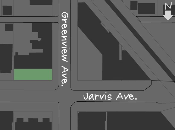
The outdoor seating areas along Sheridan Road aren't the only examples of unexpected urban plazas in Rogers Park.  At the southeast intersection of Jarvis and Greenview, just east of the el station, there's a 3-story brick and terracotta building that's substantially set back from Jarvis to create a generous plaza. 

As with many older Chicago neighborhoods, Rogers Park developed commercial districts around its public transit nodes. This was especially true around neighborhood el stations. Areas adjacent to stations functioned as primary or secondary commercial districts for the community, with development right up to the front property line.  The first floor would consist of storefronts and offices to serve the commuters, and affordable apartments would be found on the second and third floors above.

Detail of an 80-acre map showing subdivision setbacks.
Areas that were further away from transit were expected to develop as residential districts with single family homes, two- and three-flats, and larger apartment buildings like Chicago's classic courtyards. The density of any given street was based on the cost of the land; the more expensive the land, the greater number of units that could be expected.  Early development close to Lake Michigan consisted of single family homes.  But as the desirability of the area increased in the 1910s and 1920s, those same blocks began to support larger apartment buildings.

Zoning requirements in Chicago were only imposed in 1923, so subdivision setbacks, which were basically private agreements recorded to the parcels, were utilized to guarantee generous front yards and a consistent appearance of a block.   The map above shows lots the area immediately adjacent to the El  (with no setbacks)  while the green areas indicate a required 30 foot "front yard" setback.

Building footprints with Jarvis Square in green.
But, on rare occasions, the single family homes never moved in. The lots, which were still tantalizingly close to the public transit corridor, developed into standard mixed-use buildings with storefronts and offices on the first floor and apartments above. What would have otherwise functioned as a front yard became a private plaza. This seems to be what happened at the southeast corner of Jarvis and Greenview.

In recent years the Jarvis plaza has been recognized for the neighborhood amenity that it is.  It has been elaborately paved, filled with flowering plants and prairie landscaping, and enclosed with a decorative cast iron fence. The building's storefronts have seen a succession of quirky Rogers Park businesses including Don's Coffee Club, which was basically like awkwardly ordering coffee in someone's living room, as well as lefty used bookstores, black box theater companies, and antique shops. The plaza was even the site of the Rogers Park Prom (1996 to 2000?), a peculiar local event that seems to have faded into the mists of time. But the plaza is still there,  so perhaps the Prom will someday be revived, with a few ironic vintage prom dresses, a skilled DJ, and a dash of Rogers Park's neighborhood spirit.

View of Jarvis Square looking East.


Friday, September 23, 2016

Anatomy of a Small Urban Plaza

Even though American cities are primarily planned on a grid there are still idiosyncrasies in development that can allow for an unexpected amenity or two.  One of the ways in which a neighborhood rises above the unrelenting standardization of the grid is in how well local businesses recognize and utilize those spaces.

Sheridan-Columbia plaza highlighted in green.
Even in the dense areas near Lake Michigan Rogers Park has some retained some ability to bend the grid, if not actually break it.  The buildings on the west side of Sheridan between Columbia and Pratt are a good example.  The older buildings are substantially set back from Sheridan Road, creating an ideal location for a cafe or outdoor dining area.  Not all the businesses on this block take advantage of this, but those that do help to make the block attractive despite its proximity to Sheridan Road. Or perhaps because of that proximity. 

80-Acre Map detail showing subdivision setbacks in green.
Chicago established its comprehensive zoning code in 1923, but subdividers already knew restrictions could actually improve the value of their lots. Prior to Rogers Park's 1893 annexation to the City of Chicago it was subdivided in accordance with the Cook County standards defining the public rights-of-way, lot depths, block lengths, etc.  But these requirements didn't address exactly what could be built and where.

Private restrictions defining setbacks and minimum yard requirements were often recorded to the deeds of subdivision to channel appropriate development.  Those restrictions would then become part of the legal description of each parcel.

 This block (and the neighboring blocks ) were subdivided in 1890 and extensive use was made of the subdivision setback. A 30' subdivision setback line was established along Sheridan Road with 10' setbacks for the corner lots.  A 25' setback was established for Pratt and Columbia.  Interestingly, there was a diagonal setback between the lots fronting on Sheridan and those on the side streets providing a setback transition zone between the two areas.  This also made it easier to see pedestrians when coming out from the alley.

IDOT Photo detail from 1937. Overlay added to show setback.

The early development of this block was captured in a 1937 photo taken by the Illinois Department of Transportation  (Accessed through the UIC digital archives)  At that time the entire block was held to the same setback standard.  There was a vibrant mix, including a movie theater, a drug store, furrier, and even a small apartment building (you can see the steps for the apartments encroaching into the setback).  The photo looks to be taken in the fall of winter, but  there didn't appear to be much use of the plaza at this time.


Block plan showing existing development and construction dates.
The subdivision setback wasn't sacred.  Just like setbacks established by zoning ordinance there were ways it could be varied or even eliminated. Because the setback represented a private legal agreement it could be modified with the permission of the adjacent property owners.  I'm still trying to identify this exact legal mechanism, so any land-use lawyers reading this post should feel free to chime in at the comments.

In 1972 a 4-over-1 apartment building (4 floors of apartments and 1 below-grade level of parking)  was constructed in the middle of the block, extending to the front property line and disregarding the subdivision setback entirely.   But this encroachment actually provided something that the 1937 plaza was lacking- a sense of enclosure.  Without enclosure the setback just feels like an extra-wide sidewalk.

In recent years Starbucks has taken most advantage of this space, installing cafe tables, benches, and sun umbrellas.  With its proximity to Loyola University it becomes a very popular place in the warm months.  Two adjacent restaurants also make use of the plaza, although they are comparatively small.  On the north corner along Pratt there's another cafe that utilizes a portion of the setback.  Unfortunately the fence is so high that it goes beyond comfortable enclosure and makes the corner feel more like a cage. Having the opportunity for a plaza doesn't always mean establishing an outdoor room will work.  A careful balancing of space is still needed.

This isn't the only example of this type of amenity in Rogers Park.  Any favorites out there?  I'll be taking a closer look at some others in the coming months.