
 |
| Detail of Mobilgas Station at Sheridan and Devon, 1938 |
Sheridan is probably the most irregular road in Chicago, and definitely along the North Shore. It zigs and zags, primarily running North-South, but sometime jogging East or West. My impression is that it was cobbled together from various existing roads as it was extended North. So it's not unusual to have an intersection at Sheridan and Sheridan. This location is at the Northeast intersection of Sheridan and Sheridan in Rogers Park. But it's also the origin of Devon Avenue, so that's how I'll refer to it.
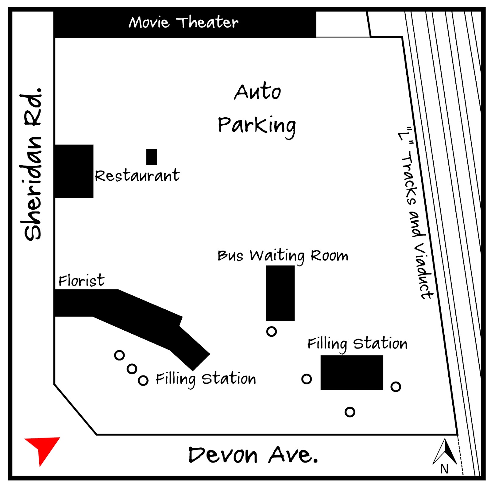 |
| Adapted from the 1937 Sanborn Fire Insurance Map |
You can see the old Mobilgas sign with the Pegasus, which was the company's symbol through the early 1960s. The station itself keys into the cottage styles that had been popular since the 1920s, complete with a small canopy over the entrance and carved timber lintels. In the background a portion of a gable roof is visible. Luckily there was a Sanborn Map created for 1937, so I can tell that this is a waiting room for the bus.
There was quite a bit going on in this lot. This filling station actually had two similar portions with hipped roofs on either end, and a flat-roofed area in the middle for the service bays. Interestingly, a florist located in the portion closest the road.
Within a hundred feet is another competing filling station, similar to the conditions at Sheridan and Juneway. These auto services tended to cluster close to each other. To the north is a small restaurant, and behind that tons and tons of parking. Not really sure about the small structure behind the restaurant. Perhaps it was a kiosk to collect fees for the parking lot? The late (and lamented) Grenada Theater was located to the north, and I'm sure the parking helped to accommodate their crowd. Do you see the little jog in the "L" viaduct behind the theater? I wondered about that, but it makes sense given the history of the property.
 |
| Click for a larger version. |
 |
| Bird's-eye view looking North |
In 1965 and 1966 the entire property was redeveloped with large concrete and brick apartment buildings with commercial uses on the first floors. These buildings can be best described as aggressively unattractive. The little buildings along Sheridan are one-story commercial buildings added recently, which have helped to make the stretch a little less alienating.
No comments:
Post a Comment