Showing posts with label IDOT. Show all posts

Tuesday, March 20, 2012

Sheridan and Albion, 1937

OK, here's the last of my images adapted from the IDOT photo archive of Chicago intersections.  This filling station at the Northeast corner of Sheridan and Albion was a particularly solid design, and I'm struck  by how similar it is to modern gas stations.  There are drive-through pumps accessible on either side for motorists who just need a fill-up,  and garage bays for more in-depth servicing.
This is one of those images that benefits from the site plan (courtesy of the Sanborn Fire Insurance Map of 1937).  The sales area and the service bays sort of pinwheel against each other, with the underground gas tanks at the rear.  I imagine the space behind was for storing cars.

If you look in the drawing you can see the outline of the adjacent house to the North, along with two huge billboards angled towards the street.  These were located on the vacant lot between the house and the filling station.  Compared to the 1930s we get off easy when it comes to signage.  Anyone with plot of land could apparently erect an enormous sign if they could find someone willing to pay for it.  Now you can't put up a sign larger than 100 sq.ft. without an order from City Council.  But I'm not a huge fan of billboards, so I'm not complaining.

It makes sense to place filling stations on the corner, where it can have access to two streets.  But why did the station itself have to be located in the center of the lot?  If I could go back in time and make a few suggestions it would be to locate gas stations on the corner of the lot and have the pumps and service areas in the back.  This would be an especially good treatment in dense urban areas, where the service station disrupts the streetscape.  This gas station was on the corner of a residential block and at least tried to retain a little grassy area near the sidewalk. 

So this might be the last gas station for a bit, although I found another good one on Clark and a tiny one on Sheridan.  I'm trying to limit thematic postings to three.  For now.  Until I return to Sheridan Road please enjoy this great pictorial  that makes use of the same IDOT photos I've been admiring.

Monday, March 5, 2012

Sheridan and Devon, 1938

Detail of Mobilgas Station at Sheridan and Devon, 1938
To the right is another image adapted from the IDOT photos of Chicago intersections of the 1930s, accessed through the CARLI collection.  These photos have an amazing amount of detail, and someone could spend years sifting through them.  The intent was to document existing traffic conditions in order to plan for future improvements, but the information contained in them goes far beyond that.  For now I'm focusing on another auto-related image.

Sheridan is probably the most irregular road in Chicago, and definitely along the North Shore.  It zigs and zags, primarily running North-South, but sometime jogging East or West.  My impression is that it was cobbled together from various existing roads as it was extended North. So it's not unusual to have an intersection at Sheridan and Sheridan.  This location is at the Northeast intersection of Sheridan and Sheridan in Rogers Park.  But it's also the origin of Devon Avenue, so that's how I'll refer to it.

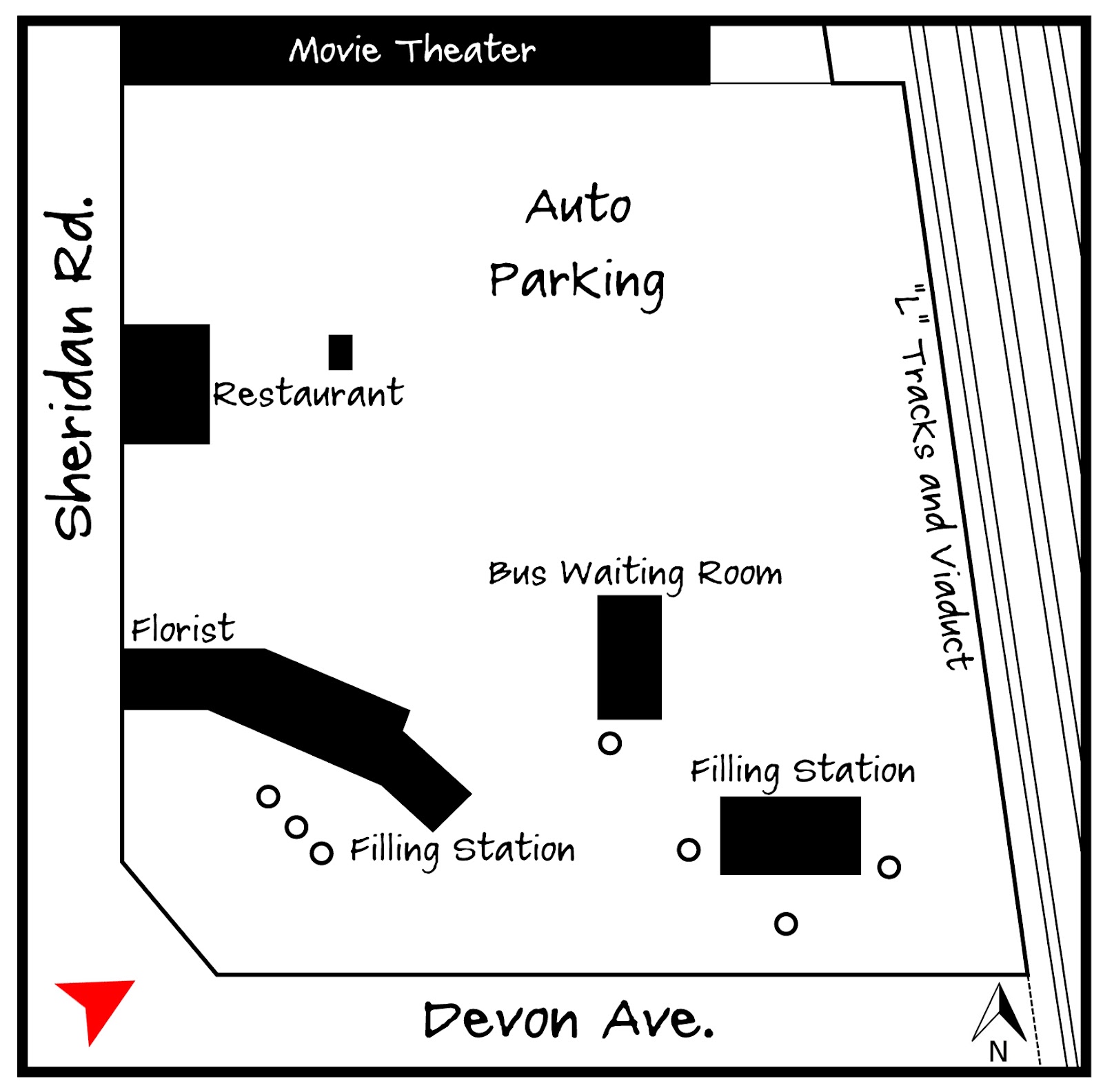
Adapted from the 1937 Sanborn Fire Insurance Map

You can see the old Mobilgas sign with the  Pegasus, which was the company's symbol through the early 1960s.  The station itself keys into the cottage styles that had been popular since the 1920s, complete with a small canopy over the entrance  and carved timber lintels.  In the background a portion of a gable roof is visible.  Luckily there was a Sanborn Map created for 1937, so I can tell that this is a waiting room for the bus.

There was quite a bit going on in this lot.   This filling station actually had two similar portions with hipped roofs on either end, and a flat-roofed area in the middle for the service bays.  Interestingly, a florist located in the portion closest the road.

Within a hundred feet is another competing filling station, similar to the conditions at Sheridan and Juneway.  These auto services tended to cluster close to each other.  To the north is a small restaurant, and behind that tons and tons of parking.  Not really sure about the small structure behind the restaurant.  Perhaps it was a kiosk to collect fees for the parking lot?  The late (and lamented) Grenada Theater was located to the north, and I'm sure the parking helped to accommodate their crowd.  Do you see the little jog in the "L" viaduct behind the theater?  I wondered about that, but it makes sense given the history of the property.
Click for a larger version.
As late as 1914 this area was a depot for the Waukesha Lime & Stone Company.  I'm used to seeing evidence of the old industrial rail connections on the Metra tracks to the west, but not along the North Side elevated. Perhaps I just didn't know where to look.  The commuter rails had been extended to Howard in 1908, but they weren't elevated until 1914 or 1915  (There's a good photo of this happening in Chicago's Far North Side, dated around 1915.)  I wonder how many other spur lines were in use before the commercial or residential value of the area won out.  The Waukesha Lime & Stone Company is still around (well, in Wisconsin), although I think they mainly supply material for road construction projects.  They probably established this depot to sell to local contractors.  Anyway, the little jutting out portion of the viaduct was constructed for these spur lines, although I'm not sure how long they were needed before giving way to the structures shown in 1937.  Regardless, the irregularity remains.
Bird's-eye view looking North

In 1965 and 1966 the entire property was redeveloped with large concrete and brick apartment buildings with commercial uses on the first floors. These buildings can be best described as aggressively unattractive.  The little buildings along Sheridan are one-story commercial buildings added recently, which have helped to make the stretch a little less alienating.


Wednesday, February 15, 2012

Sheridan and Juneway, 1937

There are many collections on CARLI but it's hard to beat the IDOT Chicago Traffic Photographs, which document hundreds of streets and intersections from the 1920s through the 1950s.  And of course there are a few from Rogers Park.  Well, more than a few.  Because the photos relate to traffic I thought it might be interesting to focus on early auto facilities in the neighborhood and see where that might lead.
N. Sheridan Road and Juneway Terrace, 1937
This sign was amazing.  It looks about 4 stories tall.  At this point Sheridan Road makes a sharp right to skirt between Calvalry Cementary and Lake Michigan, so this sign effectively terminated the view north.  In a city of regular grids it's difficult to find elements like this, which are prominent from a long way off.  Bowman Dairy was huge in Chicago, but I had no idea they had their own radio program.  I couldn't find anything online about it, but I believe the Bowman archives are at the Chicago History Museum.

Adapted from the 1937 Sanborn Map
I'm guessing that the Colonial Revival house on the left was built between 1915 and 1920.  This portion of Juneway Terrace developed with single family homes in the 1920s, while the blocks to the west were dominated by large courtyard buildings.  The owners probably were not  pleased to find themselves next to the Rogers Park auto strip, which was fully developed by the time this image was recorded.  This house was demolished some time between 1962 and 1974 and replaced with a multi-family building.

Building #2 is the primary (or at least the largest) gas station/service station in the strip.  Their gas was supplied by Shell (see the sign?) and the building had interior bays for washing and repairs.  The circles represent underground gas tanks.  The national gas chains had been building stations in a variety of traditional styles since the 1920s. These were intended to standardize the experience of the driver and develop their corporate image in a neighborhood-friendly way.  But this design, with its peculiar Mediterranean charm,  seems to be unique.

 Building #3 was an auto-oriented snack shop for hungry drivers making their way to (or from) the North Shore."Demetre from Wilmette" made me think of Plaza del Lago, the formerly unincorporated portion of the lakefront near Wilmette which became a popular entertainment district and watering hole amidst the dry North Shore.  Sure enough, there was a "Villa Demetre" serving barbequed chicken sandwiches at Plaza del Lago (then known as No-Man's Land), although it was apparently destroyed by the 1932 fire which signaled the decline of that area.  Watch the video here! The Villa Demetre sign had the number "2" above it, while this building had the number "1" above its sign.  Did this tiny snack shop come first?  Possibly.  I'm also baffled by the tiny glass enclosure at the front of the building.  Was this so you could eat your lunch and watch the traffic whizz by without choking on the fumes?  Very odd.  Plaza del Lago made use of a Spanish Mission Revival style, and this building seems to make a nod in that direction as well.

Sheridan and Juneway as it looks today.
Building #4 is another service station, this one providing gas from Texaco.  It incorporates the Spanish tile roofs seen on the other structures, and some arched details as well.  Difficult to say if this is brick or stucco. 

There was another gas station just to the east, but it wasn't included in the image from 1937 so I left it out.  But it's interesting that these auto-related businesses began to cluster from the very start.  You could see this early on in Chicago's historic Motor Row and later at the used-car lots and motels strips to be found throughout the city.  They seemed to thrive on proximity and competition.

As a side note, there was still a gas station at this location when my wife moved to an apartment half a block away in 1997.  That night their moving van was broken into and she walked over to that gas station to make a police report from their pay telephone.  Ah, the memories.