Wednesday, October 31, 2012

Veteran's Housing in West Ridge, 1946-1947


A few months ago I wrote about an example of Defense Housing in Rogers Park built for war workers in 1942.  These were the result of strict Federal guidelines permitting only defense-oriented projects to receive priority use of building materials.  With the end of the war in sight by 1944 the country began to prepare to absorb about 16 million returning veterans.  These soldiers had left in the middle of a decade-long housing shortage, and would be returning to all parts of the country, not just areas that had benefited from wartime construction. 

Below is a draft of an article intended for the upcoming issue of AREA Chicago.  It will probably change a bit once I get comments from the editors.

In September of 1946 the Chicago Tribune printed an article announcing plans for a 92 unit development intended for WWII veterans on 3.6 acres on Ridge Avenue, north of Devon. At the time this was a sparsely developed area, dotted with the single family frame houses and small truck farms which comprised much of the early character of West Ridge.

The architect was listed as Edwin H. Mittelbusher of Howard T. Fischer & Associates, Inc. Mittelbusher served as the Assistant Chief Architect for the Chicago office of the Federal Housing Administration from 1940 to 1945. Howard Fisher was the founder of General Housing, Inc. and pioneered the development of pre-fabricated housing. He served as the director of the development board of industrial housing for the National Housing Agency in 1946-1947. In short, this development was designed by people skilled at working within a bureaucracy.

Damen-Ridge Garden Apartments, 1946.  Perspective view from Ridge looking Northwest.
The project itself consists of eight two-story brick veneer buildings with hipped roofs arranged around green inner courts. The outer courts accommodate parking areas. The buildings are a restrained version of the Colonial Revival, with modern touches, such as concrete sun shades on the first floor corners and entrance stairs illuminated with large glass block windows. They were constructed as a combination of 4 and 5 room rentals. This project was initiated under the Veteran's Emergency Housing Program (VEHP), but between the time these buildings were planned and when they were completed the VEHP became functionally obsolete.

The Veterans Emergency Housing Program was developed and proposed by Wilson Wyatt, former mayor of Louisville, Kentucky, at the direction of President Truman. The initial goal was to create 2.7 million housing units within two years to serve veterans, many of whom returned to crowded conditions and shared housing situations. To accomplish this wartime price and wage controls were intended to be maintained and priority was given to housing development through a series of initiatives. The bill establishing the VEHP was signed into law in May of 1946.

Six months later Republicans took control of Congress and eliminated much of the economic controls, resulting in a sharp increase in costs in response to pent-up demands. The program had been responsible for over 1 million housing starts in 1946, but many stood half-constructed due to shortages of building materials. Soon a home that would have sold for $6000 in 1945 was priced at $8,000. This was at a time when many veterans were marrying and beginning a family. Rather than buy a home at an inflated price many chose to find rental housing. This is the era reflected by the buildings in West Ridge constructed specifically for the returning veterans.

2212-30 W. Farwell and 2213-31 W. Morse, 1946.
The construction of these brick buildings was advertised in the Chicago Tribune in November of 1946.  The architects and builders are listed as Charles and Arthur Schreiber, who established their firm in 1938 and later went on to design many modernist structures in the Southwest.  These 4 and 5 room rentals were intended to accommodate 74 veteran families.  They are similar to earlier courtyard buildings in the neighborhood, but with large sunken courts and parking along the alley.  The restrained details, portal windows, and limestone door surrounds suggest the Moderne style, which lent itself to construction on a budget. 

6102-6122 N. Hamilton, 1947.
In February of 1947 the Chicago Tribune published an article about these three buildings, which were constructed as cooperative housing for veterans and designed by architect Clarence Johnson. They're traditional in form and ornamentation, including decorative entrances, corner quoins, water tables and limestone details. These are located on wide lots but are quite shallow due to the cemetery immediately west. The cooperative ownership structure is unusual, and the article claims that this is one of Chicago's first cooperative apartment developments. Titles to these buildings were conveyed to a corporation, and each veteran buyer purchased shares of that corporation. Cooperative ownership was (and is) rare in Chicago, and has been largely eclipsed by condominium ownership. Of the three developments examined here, this is the only one which wasn't intended as a straight rental property.

While I don't intend this to be a comprehensive look at veteran's housing in Chicago (or even in West Ridge), it does provide some examples of the types of development which were feasible immediately following WWII. And in some ways it sets the stage for the suburban explosion of the 1950s, when affordable single family homes became widely available, changing the character of the American landscape.

Sources

1. The AIA Historical Directory of American Architects, 1956. Accessed online at http://communities.aia.org/sites/hdoaa/wiki/Wiki%20Pages/1956%20American%20Architects%20Directory.aspx
2. Chicago and Evanston Vet Apartment Units Approved. Chicago Daily Tribune; Sept. 8. 1946. Accessed through ProQuest Historical Newspapers: Chicago Tribune (1849-1988). Pg. NA
3. Work Started on Three New Flat Buildings. Chicago Daily Tribune; Nov.10, 1946. Accessed through ProQuest Historical Newspapers: Chicago Tribune (1849-1988). Pg. 43
4. Finish Homes in Early Vets’ Co-op Project. Chicago Daily Tribune; Feb. 23. 1947. Accessed through ProQuest Historical Newspapers: Chicago Tribune (1849-1988). Pg. WA.
5. To Hear Only Thunder Again: America’s World War II Veterans Come Home. Mark D. Ellis. Lexington Books, 2001. Accessed through Google eBooks.
6. The Veterans Emergency Housing Program. William Remington. Law and Contemporary Problems, Vo. 12, No. 1, Housing (Winter, 1947), pp. 143-173. Accessed through JSTOR.

Wednesday, October 10, 2012

Clark and Devon, 1914-2012


Bird's Eye View of the Northeast corner of Clark and Devon, 2012

To the right is a bird's eye view of the site, which I'm hoping is useful for orientation.  Below is a map chronology of the northeast corner of Clark and Devon, adapted from Sanborn Fire Insurance Maps accessed through the website of the Chicago Public Library.  These maps were originally developed to help insurance companies evaluate risk, and remain some of the best and most accurate documents to track development over time.  I've simplified the information and redrawn them.  The Ellantee Theater, the main focus of this study, is shown as dark red.  It opened for business in 1919.

Not a single building represented in 1914 is on the block presently. This is in part because an entire portion of the block was swept clean to allow an extension of the Ashland Avenue right-of-way in 1929. Here's a colorized version of the subdivision map for a bit more clarity.

From 1929 to at least 1988 Ashland ran through what had functioned as the alley behind the buildings fronting on Clark, creating an awkward triangular greenspace to the west. 


Changes in Street Configuration
The changes in the street pattern are peculiar, but it helps to map them out.  When Ashland was extended south it was also widened, which explains why the buildings along Clark had to be removed.

The section of Schreiber which extended west to Clark was abandoned. This simplified the traffic pattern and also allowed for the creation of Schrieber Playground Park, which incorporates part of the former right-of-way.

Below is a 1958 photo from Clark Street looking North toward Schreiber.
Looking Northeast Across Clark Street in 1958.  Photo from the UIC Digital Collection accessed through CARLI.

Northeast Corner of Clark and Devon, c. 1910.


Some time after 1988 Ashland was routed back to its original location, and the vacated right-of-way became a parking lot.  Perhaps this was a traffic-calming device or in response to a need for public parking.  But the photo to the right shows what was on the same corner about a hundred years ago.


 This building would have made any neighborhood proud.  It was an impressive example of a mixed-use development, with storefronts on the first floor and residential above.  I would describe the style as Italian Renaissance Revival.  But pay special attention to the arched windows on the third floor.  According to the 1928 Criss-Cross directory this was the space for the Rogers Park American Legion Post 108.  It's location on the top floor would have taken advantage of the roof trusses for additional height.

Possible Relocation
There's an undated account of the north section of this building being relocated behind the Ellantee Theater after the main portion was demolished.  If you look at the map to the left you can see that the buildings behind the theater bear a striking resemblance to part of the footprint of the building above.  I'm still trying to find a better photo of these apartments for confirmation, but the ornament on the cornice looks very similar...


As the terminus of the Clark streetcar this corner would have been a hub of commercial traffic, making the area uniquely attractive from a development standpoint.  Instead it was subjected to decades of experimentation and alteration.  

Wednesday, August 29, 2012

Ellantee Theater, 1554 W. Devon

Most people in Rogers Park know that Clark-Devon Hardware is actually a converted movie theater.  There are even remnants of the interior ornamentation, if you know where to look.  What isn't as clear is how this building changed over time, its context among similar neighborhood movie theaters, and its shifting significance to the neighborhood.
Terra Cotta Ornamentation of the Ellantee Theater

Last spring I joined the board of the Rogers Park/West Ridge Historical Society.  I'm not much of a joiner, so this was a big step for me.  At one of the meetings a brilliant suggestion was made to utilize vacant storefronts as exhibit spaces which would focus on the history of those buildings and the immediate area.  This ties in so closely to the goals of Ultra Local Geography that I couldn't pass up the opportunity to participate.  It was decided that Clark-Devon Hardware would be a good sample project.  It's not vacant, but some type of prototype project was needed.  And one of the other board members is the owner...

To the right is a lunchtime drawing of the decorative pier cap that once framed an even more elaborate parapet.   Time has not been kind to the terra cotta ornamentation on this building.  You can see remnants of the integral light sockets, which were a common treatment for theaters.  In combination with the old marquee It must have been an amazing glowing sight in its day.

So now the historical society is faced with some choices to make.  What are the goals of these storefront exhibits?  How should they be structured?  What sort of stories are they intended to tell?  I have some ideas, but this will need to be a collaborative effort.  Especially since the intent is to extend the project to other storefronts throughout the neighborhood.  I've developed a lot of methods to graphically represent development and change over time, but what about the social history embodied by the building?  How can that be made accessible in a visually intelligible way?  This should be an interesting process, and I expect to try out some ideas here first to see if they float.

Monday, August 6, 2012

Back to Ohio, Part 2

It seems like I've been traveling between Lorain and Chicago all my life.  My parents grew up in Chicago, and at least once or twice a year we would brave the 8-hour drive.  Three kids, no air-conditioning. 

The one constant factor on these trips was an overwhelming sense of boredom.  What was all this space between cities, and when would it end?  I remember listening to radio stations that were so bad even my parents knew it. I developed an ability to sleep for long stretches of time.  Mostly I remember wishing it were over.  When I moved to Chicago and reversed the trip it was still boring, but, as a driver, falling asleep on the road became less of an option.

When I finished graduate school in 1999 I had no job and few prospects.  Eventually I was hired as a part-time freelance surveyor for a historic rural resources survey in portions of unincorporated Will County, southwest of Chicago.  This was an area under heavy development and was rapidly losing  historic farms and farmhouses. 

In addition to the field work I had agreed to put together a database to contain the survey information.  But before I could do that I needed to familiarize myself with the vocabulary of agricultural construction.  This was a topic I had never explored, but since I had bluffed my way into a job I was suddenly eager to learn.

Luckily, there are some great publications out there to help explain what you're seeing and what it means.  Some of the most useful were The Old Barn Book , How to Complete the Ohio Historic Inventory, and the classic Big House, LIttle House, Back House, Barn.  But best of all were  the books put out by the government printing office and agricultural colleges in the 1920s detailing how and why farms and farm buildings should be built in certain ways.

So I spent a couple of months driving out to Will County with a big atlas, tracking down farms, taking photographs, and determining parcel  numbers at the Recorder of Deeds office in Joliet.   I got barked at by huge dogs, but was never bitten.  This is often a benchmark for a successful field survey.

But the unexpected benefit of the job was that I was no longer bored on my trips between Lorain and  Chicago.  Suddenly what I was seeing made sense. I could often guess what type of farm it was, and maybe how it fit into the history of the area.  I also began to spot more and more farms which had been enveloped by agribusiness, where the acreage seemed to soar, but the outbuildings fell into piles of decayed lumber.

On our last trip I wanted to document some of the farms west of Toledo, where there's still an unusual concentration.  These images are adapted from photos taken from the car.  Still plenty of variety, with triple gable barns, gambrel barns, different types of granaries, silos, and farm houses.  And only a few falling into ruin.  It's taken a while, but now this is a part of the trip I always anticipate.

From the 1922 edition of The Wiley Technical Series, "Farm Buildings," by Foster and Carter.
From "American Carpenter and Builder," Feb. 1916.  Accessed via Google Books.


Wednesday, July 25, 2012

Back to Ohio

Although I was born and raised in Lorain, Ohio I've been living in Chicago for the past 17 years.  Sometimes I feel like a tourist when I go back to visit family.  This isn't always a bad thing. It makes me reevaluate some of the things about Lorain that I've always taken for granted.  And somehow I've acquired another Ohio hometown-- Ashtabula, where my wife grew up and where we visit Felix and Theo's grandmother. This post is a visual record of our visit over the week of the Fourth of July.


This is an old Quonset Hut in Saybrook, OH, repurposed as a storage building.  I'm surprised how many storage buildings are found in rural areas.  Doesn't everyone have enough space?  Perhaps it's just an easy way to get some return on a large building without having to add many improvements.  Quonset huts were perfected during WWII-- easy to construct and easy to remove when no longer needed.  This one has been made permanent with a concrete "skirt" poured around the perimeter.


I believe this is an old Pure Oil Service Station which has been altered and covered with vinyl siding.  Angela tells me that it used to be a gun shop, but it looks like it's been vacant for some time.  I think this is also in Saybrook.


This is a concession stand from Geneva-on-the-Lake.  This the low budget 1920s resort strip that I've written about (and drawn) before, but it still fascinates me.  If we ever move back to northern Ohio I think it would make a good research project.


 To the left is a detail from the Bridge Street District in Ashtabula.  There's  a great collection of Italianate and Queen Anne style storefronts here,  remnants of a more prosperous time.  If there was any justice in Ashtabula this would be the most popular shopping district in the county.  You can almost feel it struggling to become the alternative to the strip malls that pass for commercial districts everywhere else.


I believe this is a grain depot in Austinburg, just down the road from our hotel.  I've never been sure of how these things work.  Somehow grains are lifted to the top of the apparatus and a separated into different grades in various containers.  They probably would be surprised if I asked for a tour.


 This is also in Austinburg.  Judging by the Greek Revival style I have to place this around 1850, if not earlier.  Due to a pesky fire in 1871 it's not possible to see buildings of this age in Chicago, although you can still find some in the suburban areas.  It looks vacant.  Even the trailer parked in front to sell overstock fireworks looks pretty run-down.


So finally we get back to Lorain, which made its reputation as a major steel city on Lake Erie.  The steel mills are still in South Lorain, but they're a shadow of what they once were.  This is a view from 28th Street.  I remember the mountains of purple iron ore that would be unloaded from enormous ships docked on the Black River.  Not as much of that anymore.


Here are some storefronts at Grove and E. 30th Street, not far from where my sister lives. They look vacant, but sometimes it's hard to tell.


And here's my last image of Lorain. A lone brick and frame cottage with bay windows. It looks like the storefront has been converted into a bar.  A very dark bar.  I'm not likely to walk into a dark bar, but maybe I'm not their target customer.

Thursday, July 12, 2012

7405-7427 N. Wolcott, Defense Housing, 1942

On the corner of Wolcott and Fargo there's a collection of eight identitical duplexes arranged around two common courts. The simple massing and limited detailing suggests public housing.  That's not far from the mark, but the story is a bit more complex.

Even though the United States didn't enter WWII until 1941, the writing was on the wall much earlier.  As the country prepared to shift into full-scale wartime production, a huge deficit in housing needed to be addressed.

Let's say you're a government and need to build some housing ASAP or risk losing the biggest war in all of human history.  Here are a few methods you might consider:

1. Buy land and build permanent homes. Or entire neighborhoods.  Or entire cities.
2. Build temporary homes.
3. Prioritize materials for war-related private projects.
4. Provide financial incentives for property owners to create additional units in existing buildings. 

In the end the Federal government did all of these things and more.  Numerous agencies were created to administer these programs, some with Congressional authorization and some without.  It wasn't unusual for the administration of one program to be folded into another, based on funding and legislation.  There must be historians who specialize in Federal housing policy, but I don't envy them. 

The Office of Production Manangement (OPM) was responsible for regulating building materials.  If a project was important to the war effort, it would receive a priority rating.  If it didn't have a priority rating it probably wouldn't get built.  Chicago was one of 275 "defense areas" identified as appropriate for the development of war housing. 

The most important restriction placed on defense housing was a $6,000 price cap per unit.  Chicago's City Council immediately protested this limitation, arguing that the higher cost of land in Chicago would send most of these projects to the suburbs.  The suburbs received their share of defense housing, but many projects did eventually locate in the city, particularly near the city limits where cheap undeveloped land could be found.
Looking East from N. Wolcott.  Behind the trees are the El and Metra embankments.
The cap forced some Chicago builders to vary from the small detached single family residences commonly built as defense housing.  Instead, developers looked for ways to combine units into larger buildings on several lots, allowing them to bring down costs through an economy of scale.  I haven't yet confirmed this, but I suspect the development regulations of Chicago were relaxed at this time to allow greater flexiblity in the placement of multi-unit buildings.  This permitted projects to share common spaces while resulting in a greater overall density.  This treatment would become common with the introduction of planned developments in Chicago's 1957 zoning ordinance, but it must have been unusual in the 1940s. The underlying lot configuration of this area would have allowed six individual buildings with frontages on Wolcott.  Instead there are eight buildings, four of which have no frontage at all. 

Defense Homes for West Rogers Park
(Chicago Tribune, 4/19/1942)

Given the strict cost limits, the design of the buildings is worth noting.  You can't get much simpler than a rectangular box with a pitched roof.  They have common brick walls with simple arched limestone entrances.  Any architectural detail is the result of projecting brick string courses of various designs.  It looks to me like a scaled-down version of  the Art Moderne style.

The architect for this project was Carl J. Kastrup, who had won prizes for his designs of low-cost suburban housing prior to the war.  In 1942 his firm joined four others to collectively address the challenges of designing and administering defense-related work.

I feel like there's much more to be written about the development of defense housing in Chicago.  In particular, it seems that the designs developed under strict economic and administrative pressure had an enormous influence on the look of Chicago in the post-war period.  But this will have to wait for some additional research.


Monday, July 2, 2012

7440-7455 N. Hoyne, 1929 - Emma Kennett Strikes Again

Figure 1. Site block plan.
On the short block of Hoyne between Fargo and Birchwood, our intrepid developer, Emma Kennett, probably created her most notable project.  These six buildings are roughly the same size and shape, but their facades were given the high-style eclectic treatment popular in the 1920s.  And of course nothing said taste and luxury quite like French and Spanish Revival. 
According to an article published in the Chicago Tribune on March 31, 1929, these buildings represented a $480,000 investment on behalf of the developer. That's nearly $6.5 million in 2012 dollars.  That was an ambitious undertaking for a small developer.  And as a side note, this was just a few months away from the onset of the Great Depression.

Figure 2. East side of N. Hoyne.

On the east side of the block are the Spanish Revival styles.  They all have various types of wrought iron balconies and a pale cream brick, which was seen as appropriate to the style.  The upper floors have casement windows and French doors, while the ground level has double-hung windows with similar pane divisions.  The casement windows alone are worth a visit.  Few original casements survive from the 20s, and this block has an impressive number.  Imagine how much these buildings would lose with simple double-hung replacements.

Figure 3. Door details

I'm particularly impressed by the door on the left.  Not only is it an arched door in a rounded tower, but the door itself is curved to match the tower's radius.  The middle door is set within an ornamental stone surround that I can only describe as Art Deco.  The simplicity of the door to the right is offset by a complex portal window, which reflects some of the arched window treatments on the block.  Two have elaborate copper kick-plates and decorative hinges attached with rivets.

Figure 4. West side of N. Hoyne.

The west side of the block is even more elaborate.  Curved towers and complex roof forms anchor these buildings, which have random-cut limestone veneers at the lower floors and brick above.  The half-timbering designs are works of art in themselves. The false mansard roofs on this side of the street are large, making them easier to read than the Spanish-style roof forms across the street. 

Figure 5. More door details.

The doors are great, each with a unique design and window pattern.  They all have the same copper kick-plates and hinges seen on the east side of the block.  And I've never seen a window pattern quite like the one found on the center door.

The Tribune article indicates that Emma Kennett designed these buildings with the help of Herbert J. Richter.  A casual internet search couldn't identify Mr. Richter.  I assumed he was the architect, but according to the Chicago Historic Resources Survey, Arthur Bucket is the architect of record.  This would make sense, since I already found Arthur Bucket's name associated with the corner apartment building at Farwell and Oakley, which I wrote about previously.  So who is Herbert Richter?  It requires some more research...

It was great to find these buildings included in the Chicago Historic Resources Survey, and it gives me an opportunity to illustrate the value of a good survey sheet.  In addition to a site map and small photograph, the surveyor also creates a narrative about the building's architectural significance.  The account below explains why architectural historians are in constant danger of walking in front of cars while wandering through the city:
Figure 6. 7451-7455 N. Hoyne
Symmetrical facade centers on semi-circular plan bay/stair tower with portal at base and topped with a hexagonal roof and finial.  Romanseque casement windows on either side of door topped with six-paned fan light.  All windows in sets of threes except baseement of simple Roman arch.  First floor fenestration repeats casement-fanlight treament with a colonade of counter-spiralled pilasters.

Third floor bays have pairs of French doors opening onto balconies flanked by smaller windows. 

Stylized Italianate eave brackets lead the eye to small windows on 2nd/3rd floors, one with ornated carved limestone surrounds and pilasters. 

Door is carved, paneled oak with semicircular leaded overglass with peep windows at eye level.  Keystones, sills, brackets and spiral columns rendered in stone.  Limestone coping on south corner gate repeats brackets at roofline. The lion finial weathervane atop tower [Did I miss this, or is it gone?], false hinges on doors and kickplate are hammered copper.
It's exhausting to read too many of these, so I'm just including this one as a representative sample.  Some descriptions are much longer.

Figure 7. L.B. Sugarman's rendering of the
west side of Hoyne. From a Chicago Tribune ad
published 
March 31, 1929.
And of course, I need to include the rendering (poorly reproduced) by L.B. Sugarman. He provided a number of perspective drawings for Kennett Construction.

Monday, June 25, 2012

Infrastructure #4

I thought I would repost this (from Feb. 2010) since CTA is actually starting to repair these stations.


This is the underpass for the L tracks at Lunt and Glenwood.  I seldom see one of these viaducts which isn't falling apart.  Instead of repairing them CTA (and Metra) tends to slap together elaborate steel supports.  Over the years water has seeped through every seam and creates little calcium formations underneath.  I wonder how long it will be until they need to replace all of these.  It would be a good opportunity to make these areas a little less creepy.

And why can't they can't get tenants for most of those little stores under the tracks?  Sure they're dark and cramped, but isn't that a selling point for some businesses?

Thursday, June 21, 2012

Clark and Estes, northwest corner 1900 and 2008

 
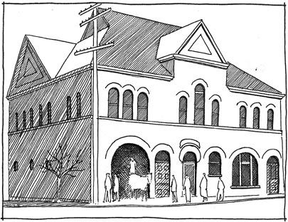
Combined Police Headquarters and Fire Department, c. 1900
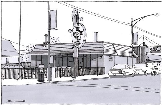
In sad recognition of the recent closing of The Washing Well I'm reposting this from December of 2008.

The drawing to the right is adapted from a collection of historic Rogers Park photos published by the Rogers Park/West Ridge Historical Society.  I've done a number of these "then and now" pairings, but this is one of my favorites.

The police and fire station at Clark and Estes also operated as the Rogers Park Town Hall prior to annexation to Chicago in 1893.

The Washing Well Laundromat, 2008


Monday, June 18, 2012

North side of Lunt, between Clark and Ravenswood

Another reprint from the 2003 booklet:
For this project the streetscape was the basic unit of information, but that wasn't really enough to understand how the buildings relate to the space around them.  For that I needed some panoramic images, but not so large that the street would be distorted beyond recognition.
This image shows the relationship of the building on the far left to the metra tracks and overpass just to the west.
And this shows the alley beween the car repair shop and the second building from the left, along with a glimpse of the taller building to the right, which has frontage on both Lunt and Clark.  Nowadays I might have chosen to add streets names for clarity.
Above is some of the information taken from the ancient permit files and the criss-cross directories I found at the Chicago Historical Society.  Sometimes I was lucky enough to find a business description on the Sanborn Fire Insurance maps.

And I couldn't leave out this auto repair shop.  Here's what I wrote about it at the time:

This repair shop and filling station was built adjoining a large horse stable to the north.  For a while you could fill up your gas tank or have your horse groomed at the same place.  The stables were later converted to light industry (screen manufacturing) and eventually demolished.  The shape of the stables explains the oddly shaped parking lot behind this building.


Later I read John Jakle and Keith Sculle's great book, The Gas Station in America, which has a chapter analyzing the transition from horse-based service buildings to car-based. I wish I had read that first, but I'll come back to it some day.

The building on the far right (the Doland Block) was saved for a page of its own.

Thursday, June 14, 2012

1254-1256 W. Albion (from 2005)

As promised, here's my entry for an apartment on Albion and Lakewood, reprinted and reformatted from Doors! Of Rogers Park! .  In this booklet I tried to start with a small detail and expand the scope out from the building into the neighborhood.

1254-1256 Albion

Date: 1925
Architect: R. J. Johnson
Owner: G. E. Halberg
Permit: A100426
File: 96890
Ledger: North 33 Page 48
Cost: $60,000
Size: 27'x116'x40'

I love the shape of this building. Faced with a triangular lot, the architect created a triangular building with a key-hole courtyard to give sufficient natural light and ventilation.

The details of these large apartments are generally not surprising, but the layouts always fascinate to me. There’s a lot to be said for not depending on air conditioning and artificial lighting. Urban architects created some great spaces to comfortably accommodate the tenants in a large multi-unit building.

Of course there are failures, too. Anyone who’s been in enough apartments must remember looking across a dim light well into a neighbor’s living room, bedroom, or bathroom. Or maybe just a blank brick wall where everyone dumps their cat-litter.

Usually the architects who designed these buildings are little known, so it’s a  pleasure to track down their names in the permit files. I feel like I’ve done some small good just uncovering that bit of history. And who knows? It might lead to the R.J. Johnson Apartment Renaissance.


Wednesday, June 13, 2012

Doors! Of Rogers Park! - 2005

The next Ultra Local Geography booklet published was in 2005.  It focused on a somewhat random assortment of apartment buildings doors in the neighborhood.  But it had a pleasant introduction, which I'm inserting below with a few minor edits:

I’m sure you’ve seen these. Maybe in an airport gift shop, or at a poster shop… maybe at a museum? They’re fairly predictable—Doors of Dublin, Doors of Philadelphia, Doors of Berlin. And of course, it’s exactly what it claims to be- doors. Sometimes there are dozens of them, usually arranged in a grid pattern. They’re old, or architecturally distinguished, or representative of a particular regional style. And I have to admit, they’re fascinating. Sometimes the images are so appealing that they’re shrunk to the size of a postcard and the details approach illegibility.

But they seem to promise more than they deliver. I wonder why they look the way they do, how old they are, what their neighborhood is like… But they’re still fascinating. Maybe it’s the sheer creativity of applying unique solutions to the same problem again and again.

But there was another element about these posters that I began to resent. A door can be a work of art, but it’s also an example of the functional beauty that surrounds us every day. What would it be like to treat these elements as relevant aspects of our everyday life? Basically, this booklet is an alternative to those posters.

[I'll be posting some of the booklet pages in the future.]


Monday, June 11, 2012

West side of Clark, between Lunt and Greenleaf, 2003


My first Ultra Local Geography publication was a xeroxed 'zine that I sold in Rogers Park for $3.  It was a history of the block bounded by Clark, Lunt, Ravenswood and Greenleaf.  I still think it was a good idea, but the drawings and organization could have been improved.  At the time I remember thinking how great it was.
I doubt anyone has seen this image for a while.  And it doesn't exactly lend itself to the vertical format of a blog.  And the last time I printed up new copies of the booklet was in 2006. 

It's interesting to see how much the block has changed since 2003.  Businesses have come and gone, facades have been repair or altered, signs and awnings have gone up (and down).  A severe fire resulted in new storefronts and brickwork for a portion of the strip.  Maybe I need to do an update on this block every 10 years or so...

Friday, May 18, 2012

6225 N. Fairfield, 1923

Here's an unusual alley building spotted by my wife on one of our innumerable drives down Granville.  She thought it might be a coach house, something I've never seen in West Ridge.  It's actually a rear lot residence and garage. Its front yard on Fairfield looks a bit like an overgrown forest.  And it's not a remnant of early development in the area either.  It was built in 1923, about the same time that the rest of the block was filling up with apartment buildings. 

There have been numerous additions over the years, so it's become an odd amalgam.  Most of it is brick, but there are several frame dormers and a tile additon on the front. There's even a little turret that's not visible in this image.

According to the permit record there was some type of carnival (with four unspecified rides) permitted on the front portion of this lot in the Fall of 1952 and 1953.  The lot to the north would have been vacant at that point, so that makes more sense. 

I remember seeing family photographs of my aunts and uncles riding ponies in their neighborhood in the 1950s . Perhaps these were the areas where local festivals were held- vacant (or underutilized)  lots on otherwise developed blocks.

Wednesday, May 9, 2012

Farwell and Oakley, 1928

Chicago owes a lot to small-scale neighborhood developers.  This role is generally unsung, despite being responsible for the overwhelming percentage of buildings throughout the city.

Adapted from the Sanborn Fire Insurance Map
To the right is a site block plan of Kennett's Subdivision, recorded in January of 1928.  The depth is about 125' (typical for Chicago) and the frontages on Farwell range from 50' to 58'.  The corner lot has  a larger frontage of 77'.  Corner lots are typically larger in order to offset the loss of a private backyard and the exposure to traffic from two directions.  In urban areas the corner lots are often used to develop a greater number of less expensive units.  This development consisted of five 6-flat buildings and one 18-flat building, although some of the 6-flats have since been subdivided. 

Emma Kennett was the head of Kennett Construction Company and an experienced developer by 1928.  The Chicago Daily Tribune wrote a number of articles about her, in part because of the novelty of a woman succeeding in the construction industry. By 1928 she had developed more than 80 buildings in the Jarvis-Ridge-Howard area while raising three young children.  Mrs. Kennett worked in the office of a builder prior to marrying James Kennett, a Chicago building contractor.  When the marriage ended Mrs. Kennett re-entered the building profession to support her young family.  And apparently also her husband, who was receiving checks from her as late as 1935, when he disappeared in California under assumptions of foul play. 

By the late 1920s she had begun developing clusters of buildings.  This subdivision is in West Ridge, but most of her work is found in Rogers Park. 

North side of Farwell, west of Oakley
In one article she notes her horror of long barrack-like apartments, which she attempts to avoid using various eclectic architectural styles popular at the time. Above you can see examples of Tudor Revival, Italian Rennaissance Revial, and Spanish Mission Revival.   She claimed to have designed these buildings herself, although she worked with architects to make the plans technically correct. I don't put this beyond her at all.  In fact, she seems to have relished the details of construction, including the interior decor, lobby ornamentation and landscaping.  Officially Arthur Bucket is listed as the architect of record for the corner building and J.T. Fortin for the 6-flats.

One thing which baffles me is her assertion that the buidings she creates resemble private homes.  And the writer totally agrees.  Maybe it's the distance of 80 years, but in no way do these look like individual homes.  They look like apartment buildings.  Even 1920s single family homes of comparable square footage (I'm thinking of the North Shore) wouldn't resemble these.  Still, the attempt to create unique buildings that avoid regimentation is certainly accomplished.

Entrances along Farwell (in order)
You have to admire the level of detail that went into these buildings.  But one of the reasons I started with this group is not because of their quality, but because their constuction and appearance is so typical for this area and this time period.

As I investigate more of these clusters I want to examine Emma Kennett's team, which included investors, architects, contractors, and even an illustrator who created perspective renderings for publication.  My guess is that her body of work will be just as consistent as that of an architect working in the same period on similar types of buildings.
____________________________

I recently received some research performed by a hugely generous reader who investigated some of the open questions in this post.  A special thanks to Marsha Holland of Edgewater, who provided the following accounts, distilled from US Census records and other primary sources accessed through Ancestry.com.  And she even found some useful Tribune articles I had overlooked.  (inserted 10/25/12)
____________________________

Herbert Richter more or less disappears after his World War II draft registration in 1942.  He seems to have drifted after his work with Emma Kennett.  At the time of the 1940 census he lived in Baltimore, Maryland, and worked as a carnival waiter.  His home in 1940 apparently was a large transient structure, perhaps the train cars that carried the circus equipment (let me know if you want me to send a pdf of the actual census pages).  He is not in the Social Security database, either because he died young or never paid in. 

Emma C. Kennett was truly a remarkable woman.  I was able to find out a good bit about her husband James’ family background but her own family of origin remains a mystery.  Her maiden name was Anderson, her parents were born in Norway, she apparently grew up in or near Chicago, and a Tribune article that I do not reference in the attached file indicates she had a sister named Mable living in Los Angeles at the time of her husband’s murder in 1935.  Someone needs to write a short biography of her for the Rogers Park and Edgewater Historical Societies, since she can be claimed by both communities as a resident.  She definitely left her mark on the city.  [Agreed! ed.]

Chicago Tribune, 23 August 1935, page 10

Article about the murder of James C, Kennett by a confessed serial killer. Kennett, who was “in the mountains for his health,” met the 21 year old man in Roseville, about 15 miles from the mine shaft in the Serra Nevada mountains where Kennett’s body was found. The killer, an itinerant prospector, said the two had met and decided to camp together, and that the murder occurred as a result of a quarrel over supplies. He claimed to have murdered 24 other people. [He was convicted and hung in May, 1936.]

Chicago Tribune, 30 August 1935, page 18
Rites Here Tomorrow for J.C. Kennett, Slain in the West
The ashes of J.C. Kennett, Sr., retired Chicago contractor, who was slain in a mining camp near Auburn, California, about two months ago, are being returned to Chicago, it was learned yesterday. Services will be held at 2:30 p.m. in the Mount Olive chapel, Irving Park Boulevard and Narragansett Street. Kennett is survived by his wife Emma of 6341 Sheridan Road, from whom he had been divorced; by two sons, James Jr., 21 years old, and Maynard, 19 years old, and a daughter Joyce, 15 years old.